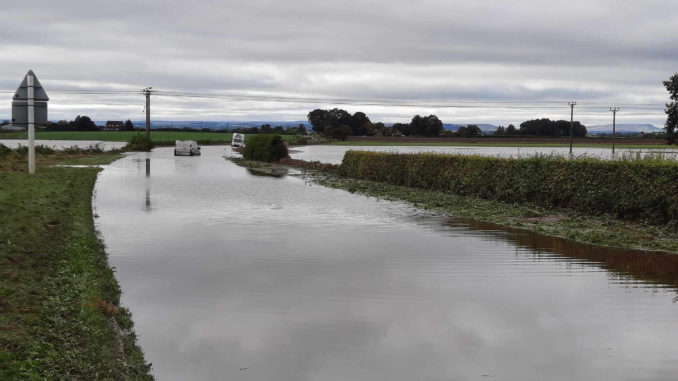
An action plan is being developed to avert thousands of motorists rat-running through villages when the River Swale floods an A-road between a county town and one of Yorkshire’s busiest industrial estates.
A meeting of North Yorkshire Council’s Richmond constituency committee was shown maps of a lengthy diversion featuring permanent signs, taking motorists to Scotch Corner and Bedale every time the Swale bursts its banks and deluges the A864 at Morton Flatts, near Northallerton.
Councillors were told while the “key strategic route” between the Yorkshire Dales and North York Moors national parks had been closed five times over the past two years.
Officers highlighted how cars had been abandoned in the floods, frustrated drivers had taken it upon themselves to take down signs, while many motorists ignored the authority’s diversion route involving other A-roads and instead used country lanes, passing through villages such as Kirby Fleetham and Scruton.
The meeting heard with 12,000 vehicles a day passing between Northallerton and the A1(M) and a significant proportion of motorists ignoring the “official diversion route”, there resulted in increased speeds through villages, damage to the lanes and people’s homes.
Residents attending the meeting said as workers travelling to Leeming Bar Industrial Estate often started from 5am and the council’s response to overnight flooding was often several hours later, villages became inundated with traffic at antisocial hours.
A highways officer told the meeting: “We are not abe to stop that traffic, we can only advise them on which is the appropriate route to take.”
To help counter the situation, the authority is set to install new and additional signs at Romanby to Warlaby crossroads this summer and is working to develop a bespoke electronic warning sign system ,similar to one which measures water levels that has been successful beside the A684 near Aysgarth in Wensleydale.
Upper Dales councillor Yvonne Peacock said the system beside the River Ure worked “exceptionally well” in leading motorists to immediately go in a different direction.
However, the meeting heard system would be subject to funding as would the authority’s long-term ambition to realign and elevate a section of the road.
Aiskew and Leeming councillor John Weighell said residents needed to know where the road would be closed when they set off from home, but the issue could be resolved with a bypass if sufficient government funding could be obtained.
Senior council figures are optimistic about the mayoral combined authority getting funding for a major road scheme following the York and North Yorkshire Local Enterprise Partnership being handed government money for a similar road scheme between Malton and Pickering about 15 years ago as the route blockages were identified as “an economic barrier”.


Be the first to comment